 |
| During a very recent visit to Vermont I had the chance to revisit some of my old favorite places, sample the terrific beer, hang out in the coffee shops and visit new places.
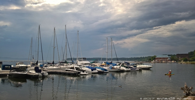
I always look forward reaching the Gilford Visitors Center, right across the state line with Massachusetts. Driving from the Washington Metro Area on I-95 and the NJ parkways, the rest stops along the way on these busy arteries are a reflection of what happens on the roads: rushed, tense, congested, a beehive of humanity. By the time one passes by Springfield, MA, the scenery and the driving experience changes and it becomes more relaxed, less frantic and the Gilford Visitors Center only an hour away. Here visitors find a barn-like structured where artisan show their products, clean facilities and a meadow around the building where one can walk among the display of old farming equipment, and during the warm months, tall grass and wild flowers. It is a welcome respite from the hard drive up to this point. Later during the week, I revisited both Montpelier and Burlington. There is a ton of work being done on the waterfront in Burlington, with a beautiful biking and hiking trail around Lake Champlain, and the lake itself silver in color, reflecting the dense clouds above it. A new experience for me this time were the Lake Champlain Islands on the northwest section of Vermont with their unique geography. Lunch from the general store at the town of North Hero – the life center of the town – and overlooking Lake Champlain was alone worth the trip because of the unique experience. The Isle La Motte has this amazing site – the Goodsell Ridge Preserve – on which one can walk on fossils that are over 480 million years old, some of the oldest in the world, a time when this area was part of the Atlantic Ocean. Some fossils show in great detail the life form of the marine animals that lived there. Sadly, some people have liked them so much that they have literally sawed them off the rocks. On the northeast of Vermont is the Northeast Kingdom and I had the chance to hike about 4 miles along the Long Trail which according to Wikipedia, “is a hiking trail located in Vermont, running the length of the state. It is the oldest long-distance trail in the United States”. And of course, there are numerous covered bridges that date back to the 1800s. Here are some pictures: http://www.austral-lights-photography.com/Other/n-GGFF4/Whats-New/ Ernesto http://www.austral-lights-photography.com
|
 |
| I have been absent from this blog for a good long time and I am trying to make amends. This blog is primarily about places and the photo opportunities those places offer so in that spirit, yesterday I visited one of my favorite places in the Washington Metro Area: Great Falls, on the Maryland side, only because it is closer to me, but both the Maryland and Virginia side are equally wonderful.
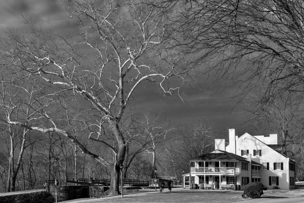
We are in the middle of an estrange winter here in the Mid-Atlantic region of the US, so smack in the middle of January, which is the harsher of the winter months, we have had temperatures reaching 70 degrees Fahrenheit. Although not as warm yesterday and today, it was about 50 degrees yesterday and partially sunny, which is wonderful for photography. Seemingly there is not much to photograph this time of the year when all around is grey and uniform in color but if we look carefully, there are many interesting things, from tree bark to moss to wildlife. This photo was taken at the “Tavern” which is the park’s visitor center and museum. There is a short history of this place at http://www.canaltrust.org/discoveryarea/great-falls-tavern/ but in essence, the Tavern was a lockmaster home which was expanded by a very entrepreneurial lockmaster in the days when the canal was in operations. Ernesto |
 |
| This is the time of the year when the cherry trees are in full bloom around here in the Greater Washington Area, and I am sure, in a lot of other places. For the last couple of years, I have made the trek to the Tidal Basin in Washington DC and I have stood in awe at the beauty of the flowering trees around the basin in the early morning, when the sun is just raising in the east and casting a magical glow on the flowers. The price of admission is that you have to be there by sunrise and you have to brave the crowds, even on weekdays.
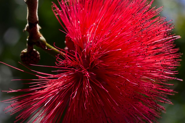
We have a cherry tree in our backyard and it blooms beautifully; it has grown from a spindly twig of a tree a few years back into a beautiful, robust specimen of a cherry tree now. I addition, we have a flowering quince bush, and both the cherry tree and the quince bush bloom at the same time, so this year, given the profusion of flowers right outside my back door, spiked with a good doses of laziness, I stayed home to admire what I have at home and photograph what I could without getting up early. Here are the results Ernesto |
 |
| So the 2016 blizzard is history. My DIY yardstick shows we got 22.5″ as measured in my backyard, and a week later half of it has already melted.
I ventured out the day after the storm and walked around Kensington and I got some pictures, not great or even good pictures, but representative of what it was. Here they are.
Ernesto |


 South River, Shenandoah National Park, Virginia, May 2015 |
| It had been a couple of years since I hiked some of the trails at Shenandoah National Park and over the last two weeks I went twice, the second time after having so much fun during the first hike.
I first I hiked a modified Rose River trail so that I could see both, the Dark Hollow and the Rose River falls. As much as I love waterfalls, it is the smaller cascades that I love seeing and the Rose River has a number of them tumbling down moss covered, timeless boulders, with the green color of the moss accentuating the gray rocks in the sunshine. The following week I hiked the South River trail at the very south end of the Central District of the park. The South River water fall is the third largest in the park but again, it is the smaller cascades rushing down the canyons that appeal to me. Having lived in the Washington Metro Area for a lifetime, I am well aware of the growth and the resulting changes that have occurred over the last 30+ years but I still marvel at the population density along the way to Shenandoah. I traveled west on I-66 (and then Rt. 29 and 211 on one of the trips) at about 7:00AM and for forty mails – forty miles! – traffic was crawling east-bound towards Washington, bumper to bumper, a numbing journey; at 7:00PM when I was coming back home, the same volume of traffic was crawling back, west-bound this time. Next day it would be the same again. Vienna, Manassas, Gainesville, and Warrenton – all points west of Washington – are unrecognizable from a decade ago. I can go on decrying the sameness of the towns along the way – malls with the same stores, the same gas stations, the same junk food joints as anywhere else (mostly) – but shortly after Warrenton, the “Virginia is for Lovers” motto becomes real: rolling hills, tree half-canopies over the road, vineyards – a great way to make Virginia even more lovable – farms, horses, still more vineyards and cellars, a lot of history and by the time one reaches Amissville, the mountains are right there in front of you. It was still early when I reached Skyline Drive. Because the higher altitude in the mountains, summer arrives just a bit later than at other places so the trees were still in the process of dressing for summer time and the ferns along the road were still uncoiling, unwinding towards the sky. Lots of history there too: the park was created when government accomplished things, when it had not been declared a “problem” yet, when the roads and facilities in the park were built by the Civilian Conservation Corps (CCC), created by the government to provide jobs to young mean during the Great Depression. That’s the good side; there is bad, too: many locals were forced to leave the area to create the park. Most hikes in the Shenandoah have one thing in common: they start at Skyline Drive on the spine of the mountains and from there the trails descend, in some cases more than 2500 feet, which makes the return to the car quite challenging. In these two hikes the altitude difference was only about 900 feet each but still, the last few hundred feet on the return leg seemed forever. Bad things can happen on these trails as some are very rocky, and when one is used to walking on nice, smooth, flat sidewalks in the city, we forget to lift our feet with every step we take so it is easy to trip on rocks, tree roots and fallen branches. A fall on these sharp rocks, if nothing else, is gonna hurt a lot. And there is the danger of miscalculating your level of fitness and how slippery the rocks can be. Garrison Keillor in his News from Lake Wobegon monolog talks about his people, the Lutherans of Scandinavian ancestry and inhabitants of the fictional Minnesota town of Lake Wobegon, and how they manage negotiating icy places by being blessed by a low center of gravity, as he put it, and that’s a good approach on the slippery trails: low to the ground; more like dragging your behinds over the rocks in my case! But the rewards are immense: streams, waterfalls, birds singing, wild flowers – mountain laurel, wild azaleas-, etc. All of the reasons why to go to the mountains. And I have the pictures to prove it! Ernesto Making Smiles into Memories |

